Archive
Technical Announcement: From Decade to Decade: What’s the Status of our Groundwater Quality?
Technical Announcement: From Decade to Decade: What’s the Status of our Groundwater Quality?
Source: U.S. Geological Survey
There was no change in concentrations of chloride, dissolved solids, or nitrate in groundwater for more than 50 percent of well networks sampled in a new analysis by the USGS that compared samples from 1988-2000 to samples from 2001-2010. For those networks that did have a change, seven times more networks saw increases as opposed to decreases.
The analysis was done by the USGS National Water Quality Assessment Program (NAWQA) to determine if concentrations of these constituents have increased or decreased significantly from the 1990′s to the early 2000′s nationwide.
“By providing a nation-wide, long-term, uniformly consistent analysis of trends in groundwater quality, communities can see whether they belong in the group of more than 50 percent which are maintaining their water quality, or within the group of more than 40 percent for which water quality is back sliding,” said USGS Director Marcia McNutt. “Communities in the latter group can decide whether and what action may be warranted to address quality issues so they do not cause concern to human health.”
Though chloride, nitrate, and dissolved solids occur naturally in the environment, human activities can cause concentrations to exceed levels that would be found naturally. At high concentrations, these chemicals can have adverse effects on human and environmental health.
High levels of chloride and dissolved solids in water don’t present a risk to human health, but are considered nuisance chemicals that can cause the water to become unusable without treatment because of taste or hardness. Additionally, these chemicals can have adverse effects on ecosystems in streams and rivers when they discharge from the groundwater to these water bodies.
Excessive nitrate concentrations in groundwater have the potential to affect its suitability for drinking water. Also, when nitrate-laden water is discharged from groundwater to streams, the nitrate can end up in downstream water bodies, such as the Gulf of Mexico, and cause algal blooms. These algal blooms lead to low oxygen zones, which can be deadly to aquatic life.
Chloride, dissolved solids, and nitrate have many sources, including agricultural fertilizers, wastewater disposal, and runoff from salt used for deicing or other chemicals. Understanding changes in groundwater quality may help assess the effectiveness of management practices that have been implemented to control these sources.
“This type of long-term trend analysis is crucial for assessing whether the nation’s groundwater is adequately protected from excessive concentrations of these potential contaminants,” said Bruce Lindsey, lead scientist on the report. “USGS is uniquely positioned to provide this type of nationally consistent, scientific information to managers at the federal, state, and local level, so that they can make decisions that protect people and the environment.”
Though a majority of the well networks tested saw no change, chloride concentrations increased in 43 percent of the well networks from the first decade to the second decade of study. Dissolved solids concentrations increased in 41 percent, and nitrate concentrations in 23 percent of well networks.
See: From Decade to Decade: What’s the Status of Our Groundwater Quality? (Science Daily)
USGS Releases Global Estimate for Undiscovered, Technically Recoverable Conventional Oil and Gas Resources
Source: U.S. Geological Survey
Excluding the United States, the world holds an estimated 565 billion barrels (bbo) of undiscovered, technically recoverable conventional oil; 5,606 trillion cubic feet (tcf) of undiscovered, technically recoverable conventional natural gas; and 167 billion barrels of undiscovered, technically recoverable natural gas liquids (NGL), according to a new assessment by the U.S. Geological Survey (USGS) released today.
The report includes mean estimates of undiscovered but technically recoverable conventional oil and gas resources in 171 geologic provinces of the world. These estimates include resources beneath both onshore and offshore areas. A fact sheet is available here.
All of these numbers represent technically recoverable oil and gas resources, which are those quantities of oil and gas producible using currently available technology and industry practices, regardless of economic or accessibility considerations. This assessment does not include reserves – accumulations of oil or gas that have been discovered, are well-defined, and are considered economically viable.
This assessment does not include the United States; however, the USGS is continuously assessing American domestic resources.
+ An Estimate of Undiscovered Conventional Oil and Gas Resources of the World, 2012
Have Floods Changed with Increasing CO2 Levels?
Have Floods Changed with Increasing CO2 Levels?
Source: U.S. Geological Survey
Only one of four large regions of the United States showed a significant relationship between carbon dioxide (CO2) in the atmosphere and the size of floods over the last 100 years. This was in the southwestern region, where floods have become smaller as CO2 has increased.
This does not mean that no strong relationship between flooding and greenhouse gases will emerge in the future.
An increase in flood magnitudes remains one of the most anticipated impacts of climate change, and land and water resource managers are asking questions about how to estimate future flood risks and develop effective flood mitigation strategies for the future.
A new report published by U.S. Geological Survey scientists in the Hydrologic Sciences Journal looks at this potential linkage using historical records of floods throughout the nation. Scientists studied flood conditions at 200 locations across the United States looking back 127 years through 2008.
“Currently we do not see a clear pattern that enables us to understand how climate change will alter flood conditions in the future, but the USGS will continue to collect new data over time and conduct new analyses as conditions change,” said USGS scientist and lead author Robert Hirsch. “Changes in snow packs, frozen ground, soil moisture and storm tracks are all mechanisms that could be altered by greenhouse gas concentrations and possibly change flood behavior. As we continue research, we will consider these and other factors in our analyses.”
+ Full Paper (Hydrological Sciences Journal)
Interior Releases First-of-its-Kind Regional Study as Part of National Assessment of Carbon Storage in U.S. Ecosystems
The Department of the Interior today released the first in a series of regional studies measuring the amount of carbon stored in U.S. ecosystems. Published by Interior’s U.S. Geological Survey (USGS), the study examines the current and projected future carbon storage in the Great Plains region, as part of a nation-wide assessment.
…
This is the first regional report applying a comprehensive methodology designed by the USGS in 2010 to assess how much carbon is stored in various ecosystems, such as wetlands, forests and rangelands. The study covers an area of the United States that includes parts of fourteen states from eastern Montana to southern Texas and eastern Iowa.Following the Great Plains study, the USGS is expected to release studies on the western, eastern, Alaskan and Hawaiian regions. The full national assessment is expected to be completed around 2013.
A key finding in the Great Plains study is that the region is currently an overall “carbon sink,” meaning it takes up more carbon than it emits. In addition, the amount of carbon sequestered offsets most of the emissions of nitrous oxide and methane from this region.
On a national scale, the amount of carbon that is currently stored per year in ecosystems within the Great Plains is about 21 percent of emissions from personal vehicles and 3.6 percent of total fossil fuel emissions nationwide. The values for vehicle and total fossil fuel emissions are not part of the USGS study but were calculated using the 2009 EPA national greenhouse gas inventory report.
Genetic Analysis Splits Desert Tortoise into Two Species
Genetic Analysis Splits Desert Tortoise into Two Species
Source: U.S. Geological Survey
A new study shows that the desert tortoise, thought to be one species for the past 150 years, now includes two separate and distinct species, based on DNA evidence and biological and geographical distinctions.
This genetic evidence confirms previous suspicions, based on life history analysis, that tortoises west and east of the Colorado River are two separate species.The newly recognized species has been named Morafka’s desert tortoise (Gopherus morafkai) and represents populations naturally found east and south of the Colorado River, from Arizona extending into Mexico.
The originally recognized species, the Agassiz’s desert tortoise (Gopherus agassizii) is listed as threatened under the federal Endangered Species Act. It represents populations naturally found west and north of the Colorado River in Utah, Nevada, northern Arizona and California.
The U.S. Fish and Wildlife Service (FWS), which manages the recovery of threatened and endangered species, had already been treating tortoises on each side of the Colorado River as distinct populations The genetic evidence simply backs up previous observations, such as differences in life history and reproductive strategies.
“The two species have different habitat preferences,” says Kristin Berry, a USGS biologist who has studied desert tortoise biology for more than 40 years and a coauthor on the study. “Morafka’s tortoise prefers to hide and burrow under rock crevices on steep, rocky hillsides, while the Agassiz’s tortoise prefers to dig burrows in valleys.”
River Levels Set Records in 10 States
River Levels Set Records in 10 States
Source: U.S. Geological Survey
Rivers and streams are reaching record levels as a result of Hurricane Irene’s rainfall, with more than 80 U.S. Geological Survey streamgages measuring record peaks.
The northeast is seeing the bulk of the records, as higher than average precipitation the past few weeks had saturated the ground in many locations prior to Irene’s arrival.
While some rivers have already crested, or reached their highest levels, other rivers are still expected to rise.
Immediately after the worst of the storm had passed, USGS hydrologists from North Carolina to Maine deployed to measure high-water marks at rivers and streams and to verify high river flows and peak stages. The crews also calibrated and repaired streamgages damaged by the storm to ensure they continued to transmit information in real time to users working to protect lives and property.
To date, records have been set on rivers and streams in Connecticut, Delaware, Maine, Maryland, Massachusetts, New Hampshire, New Jersey, New York, Pennsylvania, Vermont and Puerto Rico.
USGS Releases New Assessment of Gas Resources in the Marcellus Shale, Appalachian Basin
USGS Releases New Assessment of Gas Resources in the Marcellus Shale, Appalachian Basin
Source: U.S. Geological Survey
The Marcellus Shale contains about 84 trillion cubic feet of undiscovered, technically recoverable natural gas and 3.4 billion barrels of undiscovered, technically recoverable natural gas liquids according to a new assessment by the U. S. Geological Survey (USGS).
These gas estimates are significantly more than the last USGS assessment of the Marcellus Shale in the Appalachian Basin in 2002, which estimated a mean of about 2 trillion cubic feet of gas (TCF) and 0.01 billion barrels of natural gas liquids.
The increase in undiscovered, technically recoverable resource is due to new geologic information and engineering data, as technological developments in producing unconventional resources have been significant in the last decade. This Marcellus Shale estimate is of unconventional (or continuous-type) gas resources.
Since the 1930′s, almost every well drilled through the Marcellus found noticeable quantities of natural gas. However, in late 2004, the Marcellus was recognized as a potential reservoir rock, instead of just a regional source rock, meaning that the gas could be produced from it instead of just being a source for the gas. Technological improvements resulted in commercially viable gas production and the rapid development of a major, new continuous natural gas and natural gas liquids play in the Appalachian Basin, the oldest producing petroleum province in the United States.
This USGS assessment is an estimate of continuous gas and natural gas liquid accumulations in the Middle Devonian Marcellus Shale of the Appalachian Basin. The estimate of undiscovered natural gas ranges from 43.0 to 144.1 TCF (95 percent to 5 percent probability, respectively), and the estimate of natural gas liquids ranges from 1.6 to 6.2 billion barrels (95 percent to 5 percent probability, respectively). There are no conventional petroleum resources assessed in the Marcellus Shale of the Appalachian Basin.
These new estimates are for technically recoverable oil and gas resources, which are those quantities of oil and gas producible using currently available technology and industry practices, regardless of economic or accessibility considerations. As such, these estimates include resources beneath both onshore and offshore areas (such as Lake Erie) and beneath areas where accessibility may be limited by policy and regulations imposed by land managers and regulatory agencies.
The Marcellus Shale assessment covered areas in Kentucky, Maryland, New York, Ohio, Pennsylvania, Tennessee, Virginia, and West Virginia.
No Consistent Declines in Nitrate Levels in Large Rivers in the Mississippi River Basin
No Consistent Declines in Nitrate Levels in Large Rivers in the Mississippi River Basin
Source: U.S. Geological Survey
Despite efforts to reduce nitrate levels in the Mississippi River Basin, concentrations and transport at eight major study sites did not consistently decline from 1980-2008. These results are based on a new scientific model developed by the USGS that takes into account variation in river flows in order to gain an accurate understanding of long term trends. The results of the new USGS study are published in the journal Environmental Science and Technology.
“While conservation practices may have decreased nitrate levels in some portions of the basin, we aren’t seeing widespread effects at larger scales,” said Lori Sprague, USGS hydrologist and lead author on the report. “Applying this new model to decades of USGS water quality data allows us to distinguish between the effects of natural changes in precipitation and streamflow and the effects of purposeful changes in the management of nitrate in the basin.”
Excessive nutrients like nitrate in the Mississippi River Basin contribute to hypoxia, or dead zones, in the Gulf of Mexico. The dead zones are the result of too little oxygen to support most marine life in bottom and near-bottom water. State and federal partners serving on the Mississippi River Gulf of Mexico Watershed Nutrient Task Force are striving to decrease nutrients transported to the Gulf to reduce the size of the hypoxic zone to less than 5,000 square kilometers (about 2,000 square miles) by 2015.
For this new study, the USGS analyzed data from eight study sites taken between 1980-2008, including 3,368 individual water-quality samples and 110,732 individual daily streamflow values.
+ Nitrate in the Mississippi River and its tributaries, 1980 to 2008: Are we making progress?
See also: A New Understanding of 31 Years of Chesapeake Bay Nutrient Trends
Lichens May Aid in Combating Deadly Chronic Wasting Disease in Wildlife
Lichens May Aid in Combating Deadly Chronic Wasting Disease in Wildlife
Source: U.S. Geological Survey
Certain lichens can break down the infectious proteins responsible for chronic wasting disease (CWD), a troubling neurological disease fatal to wild deer and elk and spreading throughout the United States and Canada, according to U.S. Geological Survey research published today in the journal PLoS ONE.
Like other “prion” diseases, CWD is caused by unusual, infectious proteins called prions. One of the best-known of these diseases is “mad cow” disease, a cattle disease that has infected humans. However, there is no evidence that CWD has infected humans. Disease-causing prions, responsible for some incurable neurological diseases of people and other diseases in animals, are notoriously difficult to decontaminate or kill. Prions are not killed by most detergents, cooking, freezing or by autoclaving, a method used to sterilize medical instruments.
“When prions are released into the environment by infected sheep or deer, they can stay infectious for many years, even decades,” said Christopher Johnson, Ph.D., a scientist at the USGS National Wildlife Health Center and the lead author of the study. “To help limit the spread of these diseases in animals, we need to be able to remove prions from the environment.”
The researchers found that lichens have great potential for safely reducing the number of prions because some lichen species contain a protease enzyme (a naturally produced chemical) capable of significantly breaking down prions in the lab.
“This work is exciting because there are so few agents that degrade prions and even fewer that could be used in the environment without causing harm,” said Jim Bennett, Ph.D., a USGS lichenologist and a co-author of the study.
CWD and scrapie in sheep are different than other prion diseases because they can easily spread in sheep or deer by direct animal-to-animal contact or through contact with contaminated inanimate objects like soil. Chronic wasting disease was first diagnosed in the 1960s and has since been detected in 19 states and two Canadian provinces. CWD has been detected in wild elk, mule deer, white-tailed deer and moose in North America.
+ Degradation of the Disease-Associated Prion Protein by a Serine Protease from Lichens (PLoS ONE)
Red Knots and Horseshoe Crabs Knotted Together
Red Knots and Horseshoe Crabs Knotted Together
Source: U.S. Geological Survey
Speculation that the welfare of a small, at-risk shorebird is directly tied to horseshoe crab populations is in part supported by new scientific research, according to a U.S. Geological Survey- led study published in Ecosphere, a journal of the Ecological Society of America.
Population health of the red knot, a shorebird species whose population has plummeted over the last 15 years, has been directly tied to the number of egg-laying horseshoe crabs in Delaware Bay — between Delaware and New Jersey — during the red knot’s northward migration each spring.
“This is one of the first studies to scientifically support the ecological links between these two species,” said Conor McGowan, a USGS scientist and the lead author of the study.
The research bolsters the hypothesis that managing horseshoe crab populations and their harvest may help conserve red knots. Most horseshoe crab harvest today comes from the fishing industry, which uses the crab as bait, and the pharmaceutical industry, which collects their blood for its clotting properties.
The study, which looked at data from more than 16,000 birds over a 12-year period, revealed that the chance of a red knot gaining significant weight after arriving at Delaware Bay is directly related to the estimated number of female horseshoe crabs that spawned during the shorebird stopover period each spring. Birds that do not gain enough weight tend to have a lower chance of surviving the rest of the year, and in some years the difference between heavy and light bird survival can be large.
“Our research strongly suggests that the timing of horseshoe crab spawning, not simply crab abundance, is important to red knot refueling during their stops in Delaware Bay,” McGowan added.
+ Full Paper (PDF)
Human Activities Produce More Carbon Dioxide Emissions Than Do Volcanoes
Human Activities Produce More Carbon Dioxide Emissions Than Do Volcanoes
Source: U.S. Geological Survey
On average, human activities put out in just three to five days, the equivalent amount of carbon dioxide that volcanoes produce globally each year. This is one of the messages detailed in a new article “Volcanic Versus Anthropogenic Carbon Dioxide” by Terrance Gerlach of the U.S. Geological Survey appearing in this week’s issue of Eos, from the American Geophysical Union.
“The most frequent question that I have gotten (and still get), in my 30 some years as a volcanic gas geochemist from the general public and from geoscientists working in fields outside of volcanology, is ‘Do volcanoes emit more CO2 than human activities?’ Research findings indicate unequivocally that the answer to this question is “No”—anthropogenic CO2 emissions dwarf global volcanic CO2 emissions,” said Gerlach.
Gerlach looked at five published studies of present-day global volcanic CO2 emissions that give a range of results from a minimum of about one tenth of a billion, to a maximum of about half a billion metric tons of CO2 per year. Gerlach used the figure of about one-quarter of a billion metric tons of volcanic CO2 per year to make his comparisons. The published projected anthropogenic CO2 emission rate for 2010 is about 35 billion metric tons per year.
+ Full Paper (Eos)
The Concept of Geologic Carbon Sequestration
The Concept of Geologic Carbon Sequestration (PDF)
Source: U.S. Geological Survey
Geologic carbon sequestration is a method of securing carbon dioxide (CO2) in deep geologic formations to prevent its release to the atmosphere and contribution to global warming as a greenhouse gas. The figure illustrates some of the major concepts associated with geologic carbon sequestration. The figure is not to scale.
China’s rare-earth industry
China’s rare-earth industry (PDF)
Source: U.S. Geological Survey
China’s dominant position as the producer of over 95 percent of the world output of rare-earth minerals and rapid increases in the consumption of rare earths owing to the emergence of new clean- energy and defense-related technologies, combined with China’s decisions to restrict exports of rare earths, have resulted in heightened concerns about the future availability of rare earths. As a result, industrial countries such as Japan, the United States, and countries of the European Union face tighter supplies and higher prices for rare earths. This paper briefly reviews China’s rare-earth production, consumption, and reserves and the important policies and regulations regarding the production and trade of rare earths, including recently announced export quotas.
The 15 lanthanide elements—lanthanum, cerium, praseodymium, neodymium, promethium, samarium, europium, gadolinium, terbium, dysprosium, holmium, erbium, thulium, ytterbium, and lutetium (atomic numbers 57–71)—were originally known as the rare earths from their occurrence in oxides mixtures. Recently, some researchers have included two other elements—scandium and yttrium—in their discussion of rare earths. Yttrium (atomic number 39), which lies above lanthanum in transition group III of the periodic table and has a similar 3+ ion with a noble gas core, has both atomic and ionic radii similar in size to those of terbium and dysprosium and is generally found in nature with lanthanides. Scandium (atomic number 21) has a smaller ionic radius than yttrium and the lanthanides, and its chemical behavior is intermediate between that of aluminum and the lanthanides. It is found in nature with the lanthanides and yttrium.
Rare earths are used widely in high-technology and clean-energy products because they impart special properties of magnetism, luminescence, and strength. Rare earths are also used in weapon systems to obtain the same properties.
USGS — How does the Mississippi River Change When the Levee Breaks?
How does the Mississippi River Change When the Levee Breaks?
Source: U.S. Geological Survey
What will happen if other levees are breached downstream? Will contaminants inundate farmland? Will changes in the river’s velocity impact shipping?
USGS scientists are measuring the amount of water spilling into the New Madrid floodway as a result of the recent intentional breaching of the Birds Point Levee in Missouri. The measurements are critical for estimating how much water downstream levees will need to hold back and for predicting flood crest heights, as the remaining flood waters pass through the Mississippi River.
“In order to protect lives and property during flooding the federal government, states, emergency managers and communities need to have the best information possible to understand how the water will react when a levee breaks,” said Bob Holmes, USGS National Flood Hazard Coordinator. “While flood measurements are never routine, the recent breaching of the levee at Birds Point and the rush of the Mississippi River into the New Madrid floodway calls for highly unusual flow measurements – information that is a key part of management actions to alleviate upstream flooding in the vicinity of Cairo, Ill. and other areas along the Mississippi River.”
Up to date information about USGS data collection at the Birds Point-New Madrid floodway is available online.
USGS Economic Analysis Updated for the National Petroleum Reserve in Alaska (NPRA)
USGS Economic Analysis Updated for the National Petroleum Reserve in Alaska (NPRA)
Source: U.S. Geological Survey
The U.S. Geological Survey assessment on the economic recoverability of undiscovered, conventional oil and gas resources within the National Petroleum Reserve in Alaska (NPRA) and adjacent state waters is now available online.
This economic analysis is based on a 2010 USGS resource assessment that determined how much undiscovered, conventional oil and gas in the NPRA is technically recoverable. These reports provide updates from the USGS 2003 economic analysis and 2002 resource assessment of the NPRA.
“The USGS conducts assessment updates to re-evaluate petroleum potential as new data and information become available,” said USGS Energy Resources Program Coordinator Brenda Pierce. “Understanding how much undiscovered, technically recoverable resource might be present serves as a basis for calculating how much might be economically developed.”
Technically recoverable resources are those that could be potentially produced using current technology and industry practices. Economically recoverable resources are those that can be sold at a price that covers the costs of discovery, development, production and transportation to the market.
The new economic analysis estimates that approximately 273 million barrels of undiscovered oil are economically recoverable at an oil price of $72 per barrel (comparable to $8 per thousand cubic feet of gas). About 500 million barrels of undiscovered oil are economically recoverable at $90 per barrel (comparable to $10 per thousand cubic feet of gas). These estimates do not include the discovered oil accumulations in northeastern NPRA that have not yet been developed.
USGS Director Welcomes Independent Panel Report Confirming that Scientific Basis for New Madrid Seismic Hazard is Sound
USGS Director Welcomes Independent Panel Report Confirming that Scientific Basis for New Madrid Seismic Hazard is Sound
Source: U.S. Geological Survey
The National Earthquake Prediction Evaluation Council has issued a new report in which independent experts conclude that current USGS estimates for significant earthquake hazards in the New Madrid Seismic Zone—affecting eight central and eastern U.S states—are based on sound science.
The Council, a federal advisory committee, recently presented the report to USGS Director Marcia McNutt. Prepared by a panel of scientists from many disciplines and organizations, the report comes during the Bicentennial commemoration of the three violent “New Madrid” earthquakes and hundreds of aftershocks that struck the Mississippi River Valley in 1811-1812.“I commend NEPEC for assembling an independent expert panel to weigh scientific evidence regarding the threat posed by large earthquakes in the New Madrid Seismic Zone,” said Director McNutt. “This is an important issue that has spurred decades of excellent research on the large earthquakes of 1811 and 1812; the geologic evidence of similar earthquakes in previous centuries; and how our modern cities and towns would be shaken if similar earthquakes were to occur today.”
Professor John Vidale of the University of Washington chaired the independent panel of experts, who concluded in the report that:
- The New Madrid Seismic Zone represents a significant hazard for large earthquakes that would cause widespread damage.
- This hazard must be accounted for in urban planning and development.
- The panel does not support the view of some individuals that the region has “shut down” in its production of large earthquakes.
- The current version of the USGS national seismic hazard maps are a good estimate of the overall hazard posed by the New Madrid Seismic Zone and should continue to be used until the next revision of the maps replace them in 2013.
- Additional research could lower remaining uncertainties and thus potentially lower the potential hazard in future maps.
The New Madrid Seismic Zone overlaps eight states: Alabama, Kentucky, Mississippi, Tennessee, Illinois, Indiana, Arkansas and Missouri. It is the most seismically active area of the United States east of the Rockies. Scientists are pursuing research on numerous aspects of the hazard; this work has shown that there have been several sequences of big earthquakes during at least the past several thousand years. Because earthquakes in the central and eastern U.S. are more infrequent than in the western U.S., there are fewer observations and therefore greater uncertainties about future hazards.
+ Full Report (PDF)
Putting Down Roots in Earthquake Country—Your Handbook for Earthquakes in the Central United States
Putting Down Roots in Earthquake Country—Your Handbook for Earthquakes in the Central United States
Source: U.S. Geological Survey
This handbook provides information to residents of the Central United States about the threat of earthquakes in that area, particularly along the New Madrid seismic zone, and explains how to prepare for, survive, and recover from such events. It explains the need for concern about earthquakes for those residents and describes what one can expect during and after an earthquake. Much is known about the threat of earthquakes in the Central United States, including where they are likely to occur and what can be done to reduce losses from future earthquakes, but not enough has been done to prepare for future earthquakes. The handbook describes such preparations that can be taken by individual residents before an earthquake to be safe and protect property.
Full Documents in PDF.
The Users, Uses, and Value of Landsat and Other Moderate-Resolution Satellite Imagery in the United States—Executive ReportThe Users, Uses, and Value of Landsat and Other Moderate-Resolution Satellite Imagery in the United States—Executive Report
The Users, Uses, and Value of Landsat and Other Moderate-Resolution Satellite Imagery in the United States—Executive Report
Source: U.S. Geological SurveyModerate-resolution imagery (MRI), such as that provided by the Landsat satellites, provides unique spatial information for use by many people both within and outside of the United States (U.S.). However, exactly who these users are, how they use the imagery, and the value and benefits derived from the information are, to a large extent, unknown. To explore these issues, social scientists at the USGS Fort Collins Science Center conducted a study of U.S.-based MRI users from 2008 through 2010 in two parts: 1) a user identification and 2) a user survey. The objectives for this study were to: 1) identify and classify U.S.-based users of this imagery; 2) better understand how and why MRI, and specifically Landsat, is being used; and 3) qualitatively and quantitatively measure the value and societal benefits of MRI (focusing on Landsat specifically). The results of the survey revealed that respondents from multiple sectors use Landsat imagery in many different ways, as demonstrated by the breadth of project locations and scales, as well as application areas. The value of Landsat imagery to these users was demonstrated by the high importance placed on the imagery, the numerous benefits received from projects using Landsat imagery, the negative impacts if Landsat imagery was no longer available, and the substantial willingness to pay for replacement imagery in the event of a data gap. The survey collected information from users who are both part of and apart from the known user community. The diversity of the sample delivered results that provide a baseline of knowledge about the users, uses, and value of Landsat imagery. While the results supply a wealth of information on their own, they can also be built upon through further research to generate a more complete picture of the population of Landsat users as a whole.
+ Full Report (PDF)
Mines and Mineral Processing Facilities in the Vicinity of the March 11, 2011, Earthquake in Northern Honshu, Japan
Mines and Mineral Processing Facilities in the Vicinity of the March 11, 2011, Earthquake in Northern Honshu, Japan
Source: U.S. Geological Survey
U.S. Geological Survey data indicate that the area affected by the March 11, 2011, magnitude 9.0 earthquake and associated tsunami is home to nine cement plants, eight iodine plants, four iron and steel plants, four limestone mines, three copper refineries, two gold refineries, two lead refineries, two zinc refineries, one titanium dioxide plant, and one titanium sponge processing facility. These facilities have the capacity to produce the following percentages of the world’s nonfuel mineral production: 25 percent of iodine, 10 percent of titanium sponge (metal), 3 percent of refined zinc, 2.5 percent of refined copper, and 1.4 percent of steel. In addition, the nine cement plants contribute about one-third of Japan’s cement annual production. The iodine is a byproduct from production of natural gas at the Miniami Kanto gas field, east of Tokyo in Chiba Prefecture. Japan is the world’s second leading (after Chile) producer of iodine, which is processed in seven nearby facilities.
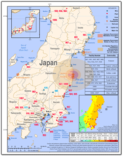
+ Full Report (PDF)
New Research Suggests Wild Birds May Play a Role in the Spread of Bird Flu
New Research Suggests Wild Birds May Play a Role in the Spread of Bird Flu
Source: U.S. Geological Survey (PLoS ONE)
Wild migratory birds may indeed play a role in the spread of bird flu, also known as highly pathogenic avian influenza H5N1.
A study by the U.S. Geological Survey, the United Nations Food and Agriculture Organization and the Chinese Academy of Sciences used satellites, outbreak data and genetics to uncover an unknown link in Tibet among wild birds, poultry and the movement of the often-deadly virus.
Researchers attached GPS satellite transmitters to 29 bar-headed geese – a wild species that migrates across most of Asia and that died in the thousands in the 2005 bird flu outbreak in Qinghai Lake, China. GPS data showed that wild geese tagged at Qinghai Lake spend their winters in a region outside of Lhasa, the capitol of Tibet, near farms where H5N1 outbreaks have occurred in domestic geese and chickens.
This is the first evidence of a mechanism for transmission between domestic farms and wild birds, said Diann Prosser, a USGS biologist at the USGS Patuxent Wildlife Research Center. “Our research suggests initial outbreaks in poultry in winter, followed by outbreaks in wild birds in spring and in the breeding season. The telemetry data also show that during winter, wild geese use agricultural fields and wetlands near captive bar-headed geese and chicken farms where outbreaks have occurred.”
The part that wild birds play in the spread of bird flu has been hotly debated since the 2005 outbreaks in Qinghai Lake. Bird flu that spread beyond Asia and into Europe and Africa was later found to have genetically originated in the Qinghai Lake area. Discovering the Tibet connection adds another significant link in the global transmission of bird flu.
From 2003 through 2009, the Qinghai-Tibet Plateau experienced 16 confirmed outbreaks of the virus in wild and domestic birds, most of them in the newly documented migratory pathway of the wild bar-headed geese. “Every summer, more than 150,000 migratory birds use Qinghai Lake, which sits within the eastern portion of the Central Asian Flyway, which extends from India to Russia,” said John Takekawa, a wildlife biologist at the USGS Western Ecological Research Center.
The study also uncovered an undocumented migratory link between Qinghai Lake and Mongolia, further suggesting that Qinghai may be a pivotal point of H5N1 transmission.
+ Wild Bird Migration across the Qinghai-Tibetan Plateau: A Transmission Route for Highly Pathogenic H5N1 (PLoS ONE)
+ FAO-USGS Avian Influenza Projects (map)
